Confined Space Drone Inspection
Confined Space Inspection Ready

Confined Space Drone
Inspection

High-resolution drone-based LiDAR scanning for buildings, shafts, tanks, and hazardous confined environments — without human entry.

Live Inspection Capture
LiDAR · Visual · Sensor Fusion
Capabilities

Our Drone Inspection Services

Our technology is designed to operate in challenging and confined environments — delivering actionable data while minimizing downtime and cost.

Work with us →

Visual Data Capture

Whether inspecting the underside of a bridge or the interior of a boiler, drones provide a superior method for capturing high-quality 4K video and still imagery.

Learn more →

LiDAR Scanning

Drone-mounted LiDAR enables the capture of high-accuracy point clouds, delivering precise spatial measurements alongside traditional video data.

Learn more →

Photogrammetry

A cutting-edge technique that converts overlapping photographs into detailed 2D maps and fully measurable 3D models.

Learn more →

Supplementary Data

Today’s drones integrate advanced sensors such as thermal, radiation, and gas detection. New capabilities like ultrasonic thickness measurement (UTM) allow safer monitoring of ship hulls, tanks, and pipelines.

Learn more →
Why It Matters

Revolutionizing
Inspection Safety

Drone inspection
Contact us →
Safety First

Safe Inspections Without Human Entry

Inspections can now be completed without sending personnel into confined or elevated environments — reducing risk and downtime.

  • No confined space entry required
  • Reduced fall and exposure risks
  • Optional gas sensing
Technology

Advanced Drone Technology

Built for precision in GPS-denied and complex industrial spaces.

  • Obstacle avoidance
  • 4K & thermal imaging
  • LiDAR mapping
Efficiency

Faster & Cost-Effective

Reduce inspection time, eliminate scaffolding, and avoid shutdowns.

Industries

Industries We Serve

Confined-space drone inspection delivering safer access, faster insights, and defensible data.

Construction

Surveys, inspections, and BIM-ready measurements.

Confined Space Inspection
Confined Area Drone Access LiDAR & Visual BIM Data
Entry Eliminated: 100%
Read more

Maritime

Hull, port, and underwater asset inspection.

Maritime Inspection Layers
Hull Surface Underwater Scan Inspection Report
Asset Coverage: 94%
Read more

Solar

IR defect detection and visual validation.

Solar Scan Logic
IR Field Heat Flux Visual Grid Anomaly Defect Map
Fault Detection: 94.1%
Read more

Nuclear

Radiation mapping and remote inspection.

HIGH ZONE SAFE PERIMETER
Read more

Oil & Gas

Pipeline and confined asset inspection.

ANOMALY SCAN VERIFY
Read more

Infrastructure

Bridges, tunnels, culverts, and sewers.

LOAD FOUNDATION
Read more

Manufacturing

Digital twins and predictive maintenance.

PHYSICAL DIGITAL TWIN PREDICTION
Read more
Process

Bringing Engineering Intelligence Through

Digital Analysis

Step 01

Consult

Contact CSDI Group to discuss your project needs, challenges, and inspection objectives.

Step 02

Plan

Receive a tailored inspection or survey plan using advanced drone platforms and digital analysis tools.

Step 03

Execute

Our team delivers accurate data, detailed reports, and actionable engineering insights.

Confined Space Capability

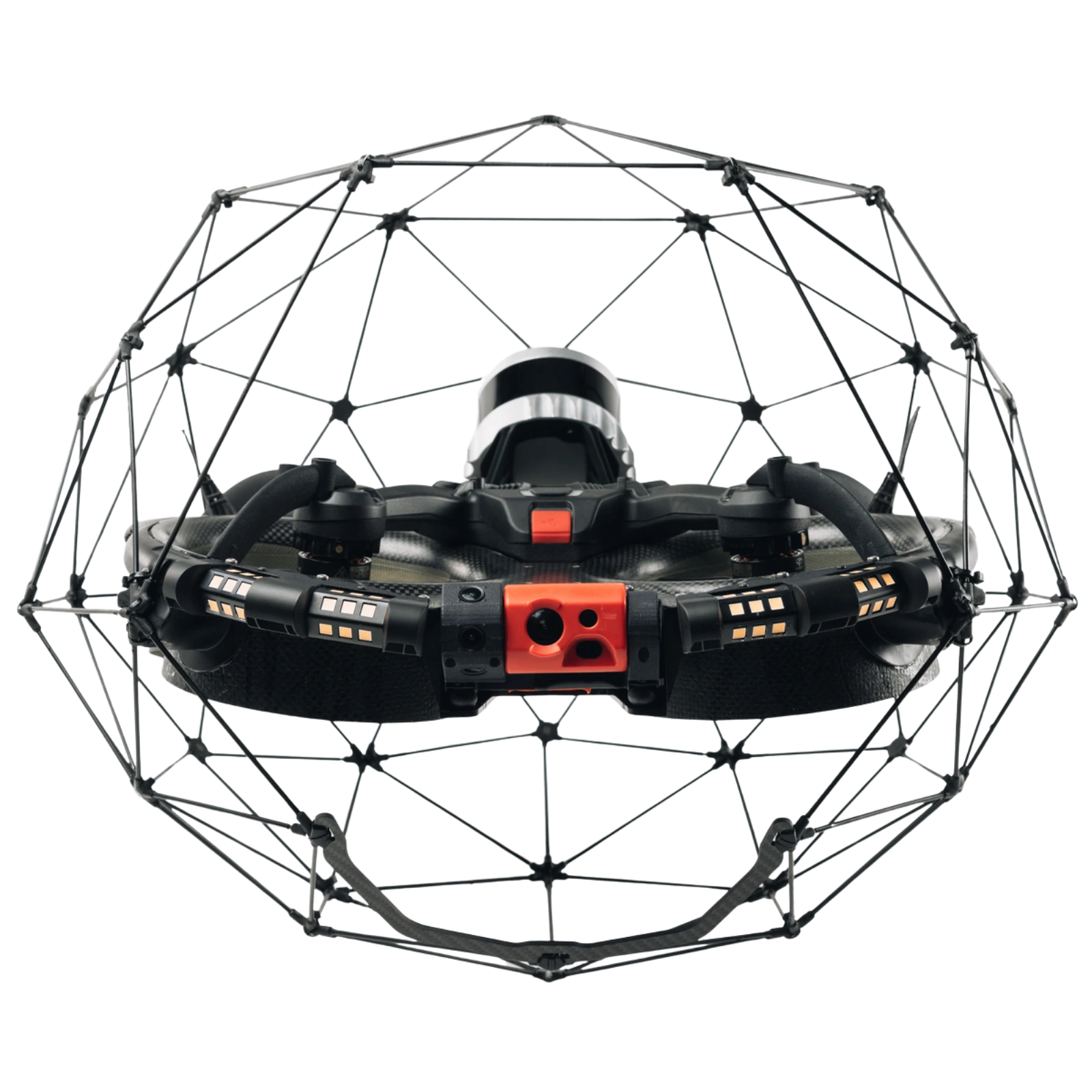
Mapping Beyond Limits

At CSDI Group, our advanced drone technology is engineered to access environments that were previously unreachable. Designed to pass through openings as small as 50 × 50 cm, our system excels in confined and complex spaces.

A fixed protective cage safeguards critical hardware, while patented flight control and motor designs allow the drone to rapidly recover stability after collisions. This enables precise navigation and high-resolution data capture in environments where traditional inspection methods fail.